Sky Shadow platform
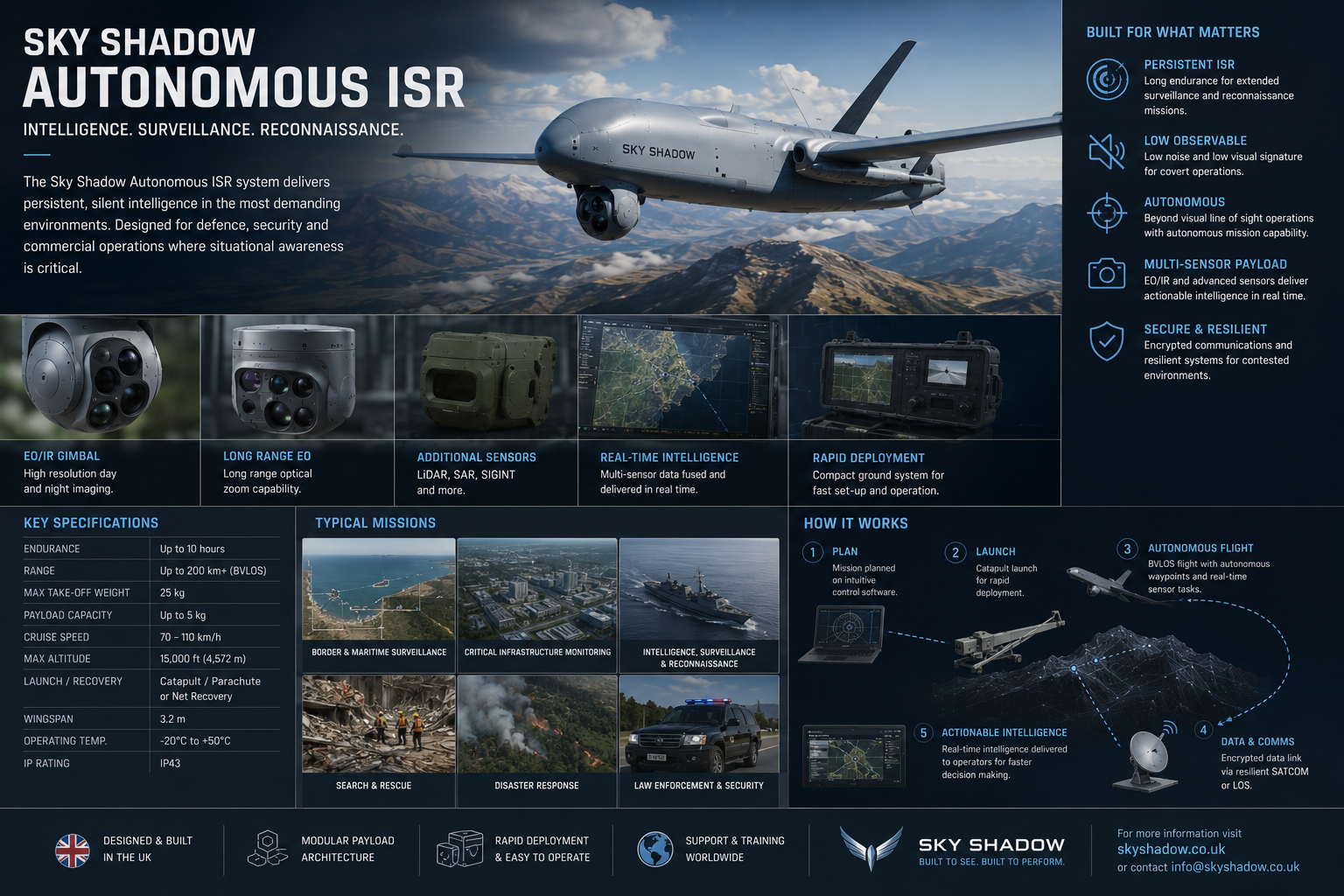
Sky Shadow ISR
Persistent aerial awareness support for coastlines, harbour approaches, offshore infrastructure routes and protected sites.
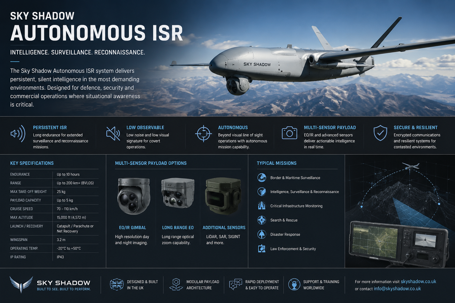
What it does
Mission value in plain terms
Sky Shadow ISR is presented as an aerial sensing and review layer inside a wider mission architecture. It can support authorised observation, route monitoring, event verification and evidence-ready reporting without replacing operator judgement.
Where it fits
Relevant Sky Shadow solution routes
This platform is selected only when it supports the operating problem, evidence requirement and human-commanded workflow.
Port and harbour security
Relevant mission route for this product family.
Coastal and EEZ awareness
Relevant mission route for this product family.
Offshore energy
Relevant mission route for this product family.
Remote-site security
Relevant mission route for this product family.
Mission workflow
Detect / observe, correlate, review, escalate and preserve evidence
Detect / observe
Collect authorised observations from the selected platform, sensor package or fixed-site layer.
Correlate
Compare the event with available maritime, site, sensor and mission-context information.
Review
Route the event into an operator-led review path with supporting context and uncertainty preserved.
Escalate
Escalate only through the agreed mission workflow, authority model and reporting route.
Preserve evidence
Retain mission logs, event context and briefing material for later review where appropriate.
Public-level specifications
Broad classes only
These notes describe public procurement-level classes. They do not provide exact values, sensitive assumptions or controlled technical data.
Integration
Connected to Sky Shadow mission software and customer systems where appropriate
SHADOWCORE
Sensor fusion, anomaly review and mission intelligence layer.
ARGUS
Multi-sensor correlation and persistent watch layer.
AEGIS
Human-commanded tasking, escalation and command workflow layer.
Research
Evidence records, mission logs, reporting and briefing layer.
Can be scoped against existing command-room workflows, site sensors, reporting processes and approved data feeds.
Pilot programme fit
Safe evaluation before scale
A safe evaluation can begin with a bounded area of interest, agreed review objectives, operator workflow validation and evidence-output assessment before any wider deployment discussion.
This public page provides a high-level description only. Detailed specifications, deployment assumptions, controlled technical data and site-specific configurations are shared through approved private briefing, NDA and compliance review where appropriate.
Product briefing
Discuss the product fit with Sky Shadow
Share the operating context, asset group, timescale and intended pilot route so the correct platform, sensing, command and evidence layers can be reviewed privately.
Holo-Fusion Ready
Air ISR with a unified mission interface.
Sky Shadow ISR deployments can feed telemetry, route status, sensor availability and observation context into Holo-Fusion, helping operators understand aerial activity as part of a wider maritime, coastal or infrastructure picture.
This platform can be configured with Sky Shadow Holo-Fusion Lite, Fusion Panel, Fusion Pro Panel or Holo Panel depending on the deployment.
Power, connectivity, mission state and health indicators.
Sensor availability, data freshness, field-of-view context and confidence-aware review.
Map, routes, operating area, alerts and replay timeline.
Spatial display mode for routes, asset relationships, sensor cones and operating-area awareness.